Areas that are prone to floods are important for urban development
Global exposure to river and coastal flooding: long-term trends and changes. That’s a good thing, says Stéphane Hallegatte
Jongman, B., Ward, P. & Aerts, J. Global exposure to river and coastal flooding: long term trends and changes. That’s a good thing. Environ. Change 22, 823–835 (2012).
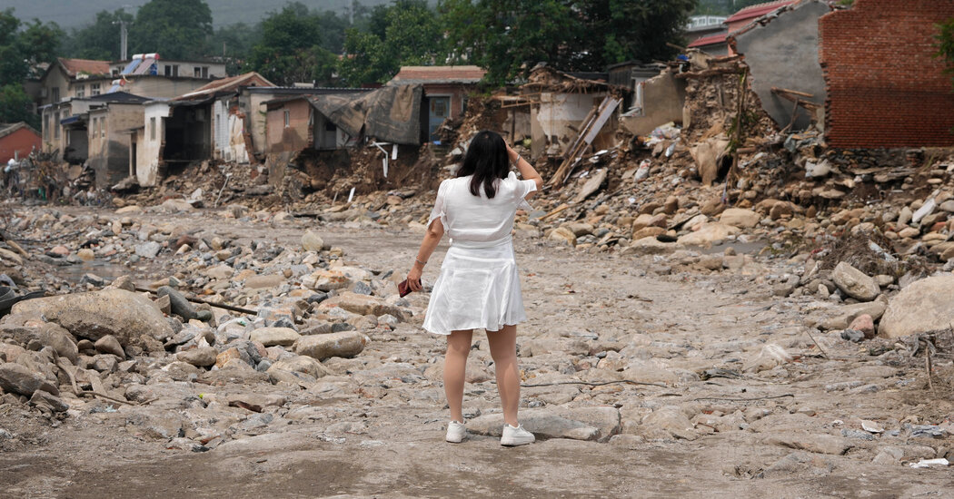
Rentschler and his co-authors found that the extent of human settlements — ranging from villages to megacities — expanded globally by 85.4% between 1985 and 2015. Development in areas that are exposed to the most dangerous floods increased 122% while growth in flood- safe areas was far less pronounced. The team’s work referred to floods resulting from rising rivers and torrential rain, as well as coastal flooding caused by storm surges and sea-level changes.
The reasons construction takes place despite the danger can be many, and Dr. Rentschler and his colleagues didn’t try to analyze which ones were most important in specific places. In some nations, the safest land might already be occupied, forcing new development to occur in hazardous areas that had once been avoided. Governments want property tax revenues as well. People want second homes. waterfront living has a certain appeal.
In the study, which was published on Wednesday, the researchers analyzed decades of satellite data to see how the physical footprints of cities and towns changed worldwide between 1985 and 2015. They compared this expansion to the current flood maps.
The most exposed region was the East Asia and Pacific. The highest percentage of all settlements in the area were prone to flooding in 2015. North America and sub-Saharan Africa had the lowest exposure, at 4.5% and 4.6% of settlements, respectively.
Some 36,500 square kilometres — roughly 6% of all land developed — was in the ‘very high’ flood-hazard category. A further 76,400 square kilometres was in the ‘high’ flood-hazard bracket — between 50 and 150 centimetres.
“When we have big disasters, it’s often because those defenses fail,” said Stéphane Hallegatte, a senior climate change adviser at the World Bank and another author of the study. He pointed to the catastrophic recent floods in Libya, where torrential rains caused two aging dams to burst, killing at least 4,000 people and displacing 43,000.
Dr. Hallegatte said that they have been working with countries to make sure they don’t assume the job is finished because of the risk.
Dr. Rentschler said he hoped that this kind of data could someday help inform government policies by tracking economic development that exposes people and structures to greater flood risk.
The key to reducing people’s exposure to climate risk is community policy and local patterns of urbanization. He describes the role of city mayors and local authorities in fighting climate change.
Hallegatte, S., Vogt-Schilb, A., Bangalore, M. & Rozenberg, J. Unbreakable: Building the Resilience of the Poor in the Face of Natural Disasters (World Bank, 2017).
The City, the Sea, and the Water: The Environ: A global flood model validation for Nigeria with extreme sea levels and storm surges
Rosenthal, S. S. & Strange, W. C. in Handbook of Regional and Urban Economics Vol. 4 (eds Henderson, J. V. & Thisse, J.-F.) 2119–2171 (Elsevier, 2004).
Tiggeloven, T. et al. Structural measures are used to analyze coastal flood adaptation to different flood risk drivers. Nat. Hazards Earth Syst. A report from theSci. 20, 1025–1044 in 2020.
The Disaster Risk Index is a tool to assess global exposure and vulnerability towards natural hazards. Nat. Hazards Earth Syst. Sci. 9, 1149–1159 (2009).
Muis, S., Verlaan, M., Winsemius, H. C., Aerts, J. C. & Ward, P. J. A global reanalysis of storm surges and extreme sea levels. Nat. Commun. 7, 11969 (2016).
Shi, J., Cui, L. & Tian, Z. Spatial and temporal distribution and trend in flood and drought disasters in East China. Environ. Res. 185, 109406 (2020).
The work confirms results from previous studies. Yu Kongjian, founder of Beijing-based landscape architecture firm Turenscape, proposed China’s ‘sponge city’ concept for urban flood management, in which concrete surfaces are replaced with green, permeable areas that can absorb water. His work found that in the three decades before 2010, 70% of new development in China was in flood plains or high-risk flood zones.
Lin, Y., McDermott, T. K. J. & Michaels, G. Cities and the Sea Level. The working papers were from the company. The abstract of this paper can be found on the following pages: http://ssrn.com/sol3/papers.
Bernhofen, M. V. et al. Global fluvial flood models were validation for major floods in Nigeria. It is called the Environ. There is a Res. Lett. 13, 10500.
Understanding current trends in global urbanisation – the World Settlement Footprint suite. A joint research centre analysis of China’s flood-zone situation
The built-up grid was derived from Landsat. European Commission, Joint Research Centre https://doi.org/10.2905/jrc-ghsl-10007 (2018).
Marconcini, M., Metz-Marconcini, A., Esch, T. & Gorelick, N. Understanding current trends in global urbanisation – the World Settlement Footprint suite. GI_Forum 9, 33–38 (2021).
The figures were very upsetting for China. The extent of settlements in the highest flood-hazard category more than tripled over three decades.
Yu explains that amongst other reasons, in China, land in flood zones is cheaper for local governments to acquire than is land with no flood risk, and it is therefore more profitable to sell to developers.
Due to the trade-offs between economic opportunity and disaster risk, there are certain places in the world that have to expand and others that don’t.
He adds that development in flood zones can also be an “uninformed choice” when flood risk assessment is poor or urban-planning regulations are inadequate.