A powerful storm in California is causing a lot of problems
California Winter Storms: Snow, Trees, Power Outages and Flood Watches in the Sonoma County, California, on Saturday
RENO, Nev. — A winter storm packing powerful winds, heavy rain and potentially several feet of snow in the Sierra Nevada shut down mountain highways, toppled trees and triggered flood watches and avalanche warnings on Saturday from the coast of Northern California to Lake Tahoe.
In 48 hours, 48 inches of snow fell in Twin Bridges, 46 inches in Lake Donner, and 44 inches in Donner Peak.
A 70-mile (112-kilometer) stretch of eastbound U.S. Interstate 80 was closed “due to zero visibility” from Colfax, California to the Nevada state line, transportation officials said. Chains were required on the mountain section of I-80.
The U.S. Forest Service issued an avalanche warning for the backcountry in the mountains west of Lake Tahoe where it said “several feet of new snow and strong winds will result in dangerous avalanche conditions.”
In Sacramento County and adjacent areas, residents were advised to avoid travel as wind gusts of up to 55 mph toppled trees and covered roads with debris, according to a tweet from the National Weather Service in Sacramento.
Parts of southwestern California remain in a flood watch through Saturday evening as San Diego is expected to receive up to 2.5 inches of precipitation.
A flash flood warning is still in effect for around 1 million people in Los Angeles, Glendale and Santa Clarita.
More than 873,000 households in the U.S. were without power as of Friday afternoon, largely in Michigan, California, Illinois and New York, according to utility companies’ reports tracked by PowerOutage.us.
San Francisco Bay Area officials reported power outages and fallen trees, some of which damaged cars and homes. In Monte Rio, a small town along the Russian River in Sonoma County, firefighters responded to several reports of downed trees crashing into homes in 50 mph wind gusts.
The Chief of the Monte Rio Fire Department told KRON-TV that there was no injuries reported after four different down trees damaged houses.
The trees were dry after several years of drought and this storm is the first big one we’ve had. “Now they’re filling up with water and beginning to topple over,” he said.
The people of California are bracing themselves for flooding, heavy snow and possibly severe storms which will last until Saturday.
There will be a flash flooding threat from the lower Mississippi Valley into the central Gulf Coast, Tennessee Valley, and southern Appalachians from Tuesday to Wednesday.
The threat does strengthen with the system heading east, so it is likely impacting a large swath of the Lower Mississippi River Valley. In Louisiana and Mississippi, there are areas that could see tornadoes, high wind gusts and damaging hail.
If the forecast holds, the second half of the storm will likely see a flurry of warnings. As we get closer to where the threat transitions from snow loads to poor roads to poor visibility and inability to travel, that will come as we get closer.
The National Weather Service office in Reno expects the December snow to be 25% of normal but it is more than that.
“It looks a lot like Christmas out here,” Deutschendorf said. It did not come with much wind and it stuck to everything. It’s like a picture postcard.
While he noted the snow totals so far are impressive, Deutschendorf said he is “cautiously optimistic” about this precipitation putting a big dent in the state’s drought.
Snowstorms that Walloped the Midwest and Central Plains: Snowfall, Ice, and Tree Damage from the Olympic Valley, California, Ski Resort
The snow covered ski resort in Olympic Valley, California wrote on their website that they were Buried.
Since the storm began Monday evening, cumulative snowfall has reached dozens of inches in some cities, including 48 inches in Battle Lake, Wyoming, 32 inches in Dupuyer, Montana, and 29 inches in Park City, Utah.
There is a giant winter storm in the US that has caused havoc, with dangerous conditions in the Great Plains, ice in the upper Midwest and severe storms along the Gulf Coast.
The coast-to-coast storm – which walloped the West over the weekend – is expected to strengthen as it pushes eastward Tuesday, and stall across the central Plains into Thursday, snarling travel amid blowing snow and freezing rain.
The storm, which first hit the Western US with much-needed snow and rain, resulted in winter storm alerts stretching from the Canadian border to the Mexican border.
“Power outages and areas of tree damage will be possible across these areas [from the Great Lakes into the Northeast], and especially for the locations seeing a combination of stronger winds and accumulating ice,” the National Weather Service predicted.
Brandon Wills, a meteorologist with the National Weather Service in Wyoming, said that the midwest and central Plains will be under a long drawn out period of snowfall.
Wills said in an Monday evening update that they aren’t expecting a quick burst of snow. Snow is “going to accumulate the highest in the northern Nebraska panhandle – and it’s going to be blowing around like crazy because of the strong winds that we’re going to have as well,” he said.
Travel through the area will be nearly impossible over the next two days according to the National Weather Service office in Rapid City.
South Dakota’s transportation department warned Monday that the interstates could become “impassible” due to the weather conditions.
It was freezing rain that could make morning travel difficult in parts of the service’s warning area, which covered central Iowa to the Wisconsin-Illinois line and through southern Michigan.
“The snowstorms that have hit Anchorage over the last week are historic in nature, bringing anywhere between 30-45 inches of snow to our city,” said Hans Rodvik, a spokesperson for the Anchorage mayor’s office, said in a statement to CNN Monday.
On Tuesday is the day you will most likely need to keep an eye on the weather because it could be the day when widespread flooding of rivers, streams, culverts and roads occurs as a result of all the precipitation coming together.
The rain was welcomed by the people of California. In the past 3 years, the state has been the driest on record.
The system that left thousands without power in Oregon and closed an interstate in Colorado will sweep through the East on Friday and Saturday. Rain showers on Saturday will hit the Northeast as some of the storms hit the South.
An average atmospheric river carries more than 20 times the water the Mississippi River does, but as vapor. Climate change is raising the stakes with millions of people likely to be affected, but California is prone to floods from these storms and major floods have happened before.
More than fifteen million people in the western part of the country are under wind warnings from the National Weather Service as a storm system moves inland.
The NWS in Portland says that strong winds with gusts of 60 mph are forecast for the Portland metro area at least until 3 pm. The coast is expected to see gusts of 50 to 70 mph.
Strong winds in Portland could knock down trees that have been weakened by weather extremes in recent years, arborist Colin Bourgeois told CNN affiliate KATU.
The heat domes of the past two dry summers have damaged the trees and taken up a lot of their energy to fight off pathogens.
The Second-Wettest Day of December 31 at the San Francisco Downtown NWS Center, and the First of Multiple System Expected to Roll across the State of California
San Francisco’s downtown NWS site recorded 5.46 inches of rain on Dec. 31 — the second-wettest day at that location in more than 170 years, the NWS said.
• Saturday: The accrual of back-to-back heavy rainfall events could lead to even more significant flood impacts possibly including rising waters and mudslides in Northern and central California. There are also possibilities of flooding and debris flows.
It was the first of several storms expected to roll across California over the next week. The current system is expected to be warmer and wet, while next week’s storms will be colder, which will lower snow levels in the mountains.
Multiple storms will reach the West Coast over the next few days. The focus is not only on the rain, snow and wind, but also on the amount of time between events that will allow the water to get in the way of the clean up.
Even after this major system Monday and Tuesday moves out, the possibility of yet another impactful system is already on the horizon. At the end of the week, we are starting to get some information on how the new system will affect Northern California.
That means New Year’s Eve celebrations Saturday will likely be dampened in New York City and Washington, DC. Los Angeles is also expected to ring in a wet new year.
There was a flood watch in effect in Northern California through New Year’s Eve. Residents were urged to get prepared for the potential overflow of rivers and streams.
New York City Forecasts for Super-Energy-Low-Temperature Rainfalls Through the Afterglow of Dec. 20
The heaviest rain is predicted between 7 and 1 a.m. Sunday in New York City. Temperatures will be near 50 through most of the afternoon into Sunday.
The Weather Prediction Center said that the slight risk area highlights places that are already high in soil moisture, burn scars and urban areas.
A stretch of I70 in Colorado reopened Thursday after it was closed for nine hours due to storms and mountain snow.
State police said five people were killed in Oregon on Tuesday when trees fell on passing vehicles.
Landslides already had closed routes in the San Francisco Bay Area, between Fremont and Sunol, as well as in Mendocino County near the unincorporated community of Piercy and in the Mendocino National Forest, where crews cleared debris into Friday night.
The earthquake that struck on Dec. 20 caused roads to begin to flood, according to the National Weather Service. The bridge that was temporarily closed last week because of earthquake damage may be closed again if it gets too high, according to officials.
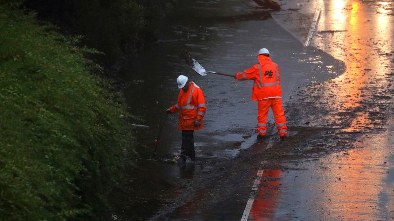
Weather service meteorologist Courtney Carpenter said the storm could drop over an inch of rain in the Sacramento area before moving south. The chair lifts were closed at the ski resort due to flooding and operational problems as well as a picture of the lift tower with empty chairs surrounded by water.
Sacramento’s fire officials planned to broadcast evacuation announcements from a helicopter and a boat along the American River — a spot where many unhoused people live in encampments — to warn of flooding.
The weather service in Reno said strong winds could cause tree damage, and the waves may cause small vessels to capsize.
“Flooding impacts continue to escalate as this rain continues with too many road closures to count at this point,” NWS said Saturday, telling residents to stay put amid reports of rock and mudslides across the foothills and road closures across the Sierra passes.
At Susanville, California about 85 miles (137 kilometers) north of Reno, the Susan River was forecast to rise from about 5 feet (1.5 meters) Friday to a foot (30 centimeters) above the flood stage of 12 feet (3.6 meters) by Saturday morning, causing moderate flooding that could affect some homes, roads and bridges, the National Weather Service said.
California’s driest storm on record: Flood warnings for the Sacramento Valley and Watsonville, and the national weather service in Sacramento
The rain was welcomed in drought-parched California, but much more precipitation is needed to make a significant difference. The past three years have been California’s driest on record.
The weather agency said there was too many road closings to count. Residents in the unincorporated community of Wilton were urged by the county to flee because of flooded roads.
The California Highway Patrol said on their website that the roads are extremely slick so it’s necessary to slow down. State Route 50 was one of the highways that reopened.
A car that appeared to be stuck in water and a railroad underpass that was flooded were both posted by the police department.
It was the first of several storms expected to roll across the state in the span of a week. Saturday’s system was warmer and wetter, while storms this week will be colder, said Hannah Chandler-Cooley, a meteorologist at the National Weather Service in Sacramento.
The storm wreaked havoc on northern California as it flooded many streets and caused several small communities in the region to be evacuated on New Year’s Eve.
On top of urban flooding, several rivers began overflowing, including the Cosumnes and Mokelumne rivers and the Mormon Slough, according to the National Weather Service in Sacramento. Flood warnings were issued for the southern Sacramento Valley and Sierra foothills.
Three communities near the city of Watsonville were also told to evacuate by the Santa Cruz County Sheriff’s Office due to creek flooding, while the rising San Lorenzo River waters prompted evacuations in the communities of Paradise Park and Felton.
Highway rescue and reopening in Amador County after the storm of December 26, 2017, noted the Los Alamos State Park, which had over 10 inches of rain on December 26
During the day on Saturday, fire crews were kept busy, performing water rescues, responding to fallen trees, and disabling vehicles for drivers who got stuck in standing water.
According to the Sheriff’s Office of Amador County, there have been reports of flooding, mudslides, and trees blocking roads during the recent storm dubbed “Stormageddon”.
Shortly after midnight the section between Pollock Pines and Meyers was open again after being closed due to flooding from the American River.
The state of emergency was declared by the county due to the flood caused by the atmospheric river.
Indeed, San Francisco experienced its wettest 10-day period on record for downtown since 1871, according to a Thursday tweet from the local weather service. The area soaked up more than 10 inches of rain between December 26 and Wednesday, the agency said.
Work will take place across the mountain since the lifts were coated in ice and the danger of an avalanche is extremely high according to the ski resort.
At the Nevada State line and Colfax, CHP reported “dangerous and treacherous” driving conditions with dozens of vehicles stuck on the I-80 and county roads.
Dozens of drivers were rescued on New Year’s Eve along Interstate 80 near Lake Tahoe after cars spun out in the snow, the California Department of Transportation said. The key route to the mountains from the San Francisco Bay Area reopened early Sunday to passenger vehicles with chains.
Cars were submerged in flood waters from Highway 99 and the Dillard Street area on a CNN affiliate video. Chris Schamber, the fire captain with Cosumnes Fire Department, told the station that many people had been rescued.
The Pasadena Stream Floods and Mudding Slides During the Rose Parade: New Year’s Resolution and a Rejoinder
With the region drying out on New Year’s Day and no rainfall expected during Monday’s Rose Parade in Pasadena, spectators began staking out their spots for the annual floral spectacle.
At least two people died in the storm, including one who was found dead inside a completely submerged vehicle Saturday in Sacramento County, and a 72-year-old man who died after being struck by a fallen tree at a Santa Cruz park, according to officials.
An evacuate order was given for the rural areas of Point Pleasant, as well as Glanville Tract and Franklin Pond.
“It is expected that the flooding from the Cosumnes River and the Mokelumne River is moving southwest toward I-5 and could reach these areas in the middle of the night,” the agency tweeted.
The new year message for people in Northern California who have been affected by floods and mudslides is that it could get worse before it gets better.
The office said that there are now some parts of the Russian River that are at risk of flooding. The NWS also says the storm’s high winds could inflict severe damage in areas where the soil is already saturated with rainwater.
Mary Spencer- Gode and other residents went to the damage of the elm tree that was knocked down on New Year’s Eve.
“The wind was just going crazy,” she told Capital Public Radio. “We turned our TV off so we could hear it, and I was sitting in the kitchen, I heard a big ‘woosh’ and kind of the house moved.”
Forecasting a Cold Front and a Giant Pion-Cabin Tree Storm in Calaveras Big Trees State Park
Bob Oravec, senior forecaster for the NWS, recently told NPR that a narrow area of high water that is moving away from the tropics to the higher latitudes is often where a cold front will arrive.
For states along the West Coast, atmospheric rivers are “actually responsible for a good majority of the rainfall during the colder season, which is the season when they get most of their rain,” Oravec said.
NPR has reported that a single atmospheric river could carry more water than the Mississippi River at its mouth. Forecasters have long warned that the systems’ winds are very dangerous. In 2017, one of the storms toppled the legendary “Pioneer Cabin Tree” sequoia in Calaveras Big Trees State Park.
It could start to affect the land as early as Tuesday night, according to the forecasters. The system was still moving slowly, as of Wednesday morning, and they had predicted it would.
“The most intense part of the weather event is going to last through Thursday noon,” said the NWS office in Los Angeles. A cold front will suck the rain out of a river.
“With the heavy rain expected, and already very wet soils in place, there will be an increased risk for rock/mudslide activity in the local mountains and canyon roadways,” the weather service in Los Angeles said.
California’s Bomb Cyclone Smashes Wednesday Night: Heavy Rains, Winds and Winds Enforced by a Category 5 Storm
The bomb cyclone slammed into California Wednesday night, unleashing heavy rains and winds that were as strong as a Category 5 storm.
Mary Ellen Camily is the Executive Director of San Francisco’s Department of Emergency Management. A few of the roads in our city are seeing a little bit of water coming out of them. There are no significant mudslides at this point. But the more rain we get and the less time in between, we know we’re going to see more of those conditions,” Carroll told CNN.
As wells run dry and reservoirs drain, Julie Kalansky, a climate scientist at Scripps Institution of Oceanography in San Diego, said these storms are desperately needed more than ever to alleviate the drought, despite the hazards they bring in some areas.
“They’re two sides of the same coin: they can be extremely beneficial because they bring so much of California’s water supply to the state or they can also be drought busters,” Kalansky told CNN. It can lead to flooding if the duration gets too long and the landscape does not get the chance to absorb all the rain.
According to a study done in 2022,climate change has significantly increased the chance of a disaster in California, such as a megaflood, in the next four decades.
Because of the yearslong drought, the ground can only absorb so much water and in many areas has already reached its saturation point from storms in late December and over New Year’s weekend. Major flooding in some places is expected due to the influx of water.
Nancy Ward, a new director of the California Governor’s Office of Emergency Services, said at a late morning news conference that “this may be one of the most challenging and impactful storms to touch down in California in the last five years.”
People were told on Wednesday that they should be prepared for potential power failures, as well as for travel to be threatened by high winds, fallen trees and power lines.
An onset of severe weather across the West Coast has spawned unfamiliar wintry conditions at higher elevations, particularly over mountainous areas of Los Angeles and Ventura counties, where up to a foot of snow may pair with 80 mph winds, the National Weather Service said.
California Bomb Cyclones, Powerful Winds: Emergency Assistance in the Response to the 2018 Los Alamos Mud Slide Down Montecito
The governor of California issued an emergency declaration Wednesday in order to quickly mobilize aid for those affected by the storm, which has beenwreaking havoc on the state.
The state said that there were firefighters and rescue equipment in burn scar areas as the storm moved towards California.
Among the areas ordered to evacuate is Montecito, the site of a mudslide in 2018 that killed 23 people as mud and boulders the size of houses plowed down the Santa Barbara hillsides, splintering more than 100 homes and rupturing a gas main, according to the state’s Office of Emergency Services.
Das Williams is the first district supervisor in Santa Barbara County. “If you live in that red zone, the one thing that we should’ve learned these past five years is that it’s better to play it safe and to evacuate and comply with the order.”
Officials in Monterey County also started setting up evacuation points and emergency shelters ahead of the storm’s arrival, according to the sheriff’s Facebook page.
The section of coastal Highway 1 that was closed due to rock slides was from Ragged Point in San Luis Obispo County to the south of Big sur in Monterey County.
Mary Ellen Carol, the executive director of San Francisco’s Department of Emergency Management, said the city had already seen some flooding and mudslides.
A family was trapped in a car and pictures were shared by the San Francisco fire department of a crew working to get the tree out of the car.
Source: https://www.cnn.com/2023/01/05/weather/california-bomb-cyclone-flooding-powerful-winds/index.html
Oakland County Sheriff’s Office reported a heavy rainstorm Wednesday night that killed 19-year-old woman and pedestrian intruder in Santa Margherita
And earlier in the day, there were reports of falling glass from a downtown high rise in Fox Plaza, though no injuries were reported. “It is unknown at this time if this is wind-related – highly possible though,” the San Francisco Fire Department said in a tweet.
Across the bay, Oakland city officials declared a local emergency Wednesday, bracing for storm damage on Oakland roads, flooding and potential threats to public safety.
California’s largest gas and electric utility company, Pacific Gas and Electric, reported the storm was damaging its equipment and causing widespread outages Wednesday evening.
A large number of trees falling into our lines, as well as other impacts on our power system was reported by Teresa Alvarado, the public affairs officer for PG&E. “We’ve mobilized for a major repair and restoration effort.”
Aaron Johnson, vice president of PG&E’s Bay Area region, said hundreds of crews are staged around the region, including some from Southern California Edison who are also aiding in the response.
According to Johnson, the storm may make it difficult for crews to access some areas that are without electricity.
The storms will be ranked up there with one of the storms that I’ll remember, said a meteorologist in a video on the company’s page.
After much of California was lashed with heavy rain and damaging winds Wednesday and Thursday that flooded roads, toppled trees and knocked out power to most across the state, daytime Friday will bring some relief before another storm moves in at night.
Excessive rain proved deadly Wednesday when a 19-year-old woman died after crashing her car into a utility pole on a partially flooded road in Northern California, the Fairfield Police Department said. The driver hydroplaned and lost control of the vehicle before hitting a utility pole, police said.
A young child was killed Wednesday when a tree fell on a home in Northern California, according to a fire department chief.
Combined Effects of El Nio and La Nia Predictions on Local Streams, Creeks, and Rivers
Mary Ellen Carol, the executive director of the city’s emergency management department said that some people saw flooding, mudslides and sinkholes in San Francisco.
If the population of California looks in the right direction, they’ll be able to see snow later this week. In California’s major cities, snow is unlikely but it will fall nearby.
The saturated ground from record rainfall earlier this week and the new precipitation this weekend can cause damage even when the wind is just 40 mph.
The rainfall over the weekend brought renewed flood concerns for local streams, creeks, and rivers. The Colgan Creek, Berryessa Creek, Mark West Creek, Green Valley Creek, and the Cosumnes River all have gauges that are currently above flood stage or expected to be in the next few days.
El Niño and La Niña forecast patterns put out by the Climate Prediction Center give guidelines on what the overall forecast can be during a seasonal time period.
“During a La Nia, the Pacific Northwest typically sees wetter than normal conditions, while Southern California usually sees dry conditions,” Marybeth Arcodia said. “This is due to the jet stream being pushed farther north and having a wavier pattern. It’s not a word
“Atmospheric rivers typically form during the winter months and can occur during El Niños or La Niñas,” Arcodia said, noting their strength, frequency, and landfall location can be influenced by the larger patterns in the Pacific.
Forecasts for Heavy Rainfall, Power and Communication Systems, and the Effect of the High Snowfall Rate on the Pacific Northwest, as Seen by CNN Weather Brief
The entire season as a whole is what Michael Tippett, a professor of physics and mathematics at Columbia University points out. This is why researching the patterns is so important.
There is randomness that is not explained by the patterns. This might show us why a year is different.
Michael Anderson, the state climatologist, told a news conference late Saturday that officials were paying close attention to three other weather systems in the Pacific and were keeping an eye on Monday’s storm.
The city’s communications infrastructure, cellular and internet, is underground so “as we get more inundation from the rain, we’re seeing more failure around those, what we call lifeline systems” for power and communication, said Carroll.
The prediction center has elevated the risk of excessive rain for about 15 million people in the state on Monday to a Level 3 out of 4. A Level 4 out of 4 warning may be necessary for Monday if the forecast guidance continues to go up, the prediction center wrote in their discussion on Sunday.
“Overall, there is high confidence (60-80%) that this wetter-than-normal pattern will continue through the next couple of weeks,” the weather service in San Francisco said. We don’t have details on how much rain is going to fall but we can say that the continuation of wet soils could pose a hazard into the third week of January.
Editor’s Note: A version of this article originally appeared in the weekly weather newsletter, the CNN Weather Brief, which is released every Monday. You can receive them every week if you sign up here.
The storm is already showing signs of life along the West Coast, as snow and rain is already falling across the Pacific Northwest, adding to their already blockbuster snow season.
The Pacific Northwest has the potential to see gusts of up to 60 mph and the highest peaks in theCascade Mountains could get as much as three feet of snow through Tuesday. Seas just offshore will be as high as 20 feet, bringing large, breaking waves to coastal areas, causing beach erosion.
“This amount of snow will result in the passes needing to be closed for a period of time which will impact traffic getting to and from Los Angeles,” The National Weather Service office in Hanford, California said.
There are warnings for southern Wyoming where there is nearly two feet of snow and winds over 70 mph, which will cause blinding conditions. The wind chills are 25 degrees below zero according to the weather service.
The weather is going to be icy in the big cities, including Chicago. Ice could also be a problem for parts of the Ohio Valley, yet pinpointing exactly where it will occur is challenging this far out. Stay tuned with the forecast if you live in these areas, because freezing rain and sleet could halt your travel plans and even cause power outages.
The storm will hit the Northeast and New England by the end of the week. Boston could get a couple of inches of snow, although New York City might not get as much.
We could set more than 130 high temperature records across the Southeast while more than 40 low temperature records could be set across the Northwest.
Whether you are buried under three feet of snow and experiencing frigid temperatures or basking in the sunshine and record warmth, this week will touch nearly all corners of the country with wild weather.
The state National Guard, transportation department and the state patrol were directed by the Gov. to be prepared to respond to storm impacts.
Air Transportation in the Midwest During Winter Storms: A Statewide Snowflake Warning and Its Extension to Minnesota, Wisconsin, and the Dakotas
Airports across the Midwest, including in Minneapolis, Chicago, Milwaukee and Detroit have faced a plethora of cancellations. On Wednesday, more than 1,600 flights were canceled and another 5,200 were delayed. Thursday brought more of the same — more than 1,700 flights were canceled and almost 10,000 delayed as of Thursday morning, according to FlightAware.
The cancellations come as more than five million people are under ice storm warnings across northeastern Iowa, southern Wisconsin, northwestern Illinois and southern Michigan. There are over two million people under a winter storm warning in Wyoming, Minnesota, Wisconsin and the Dakotas.
Snow is falling at heavy rates of 1-2 inches per hour near the Great Lakes, and combining with 40-50 mph winds. It will result in significant impacts that will include major disruptions to travel, infrastructure, livestock and recreation.
South Dakota’s governor announced Tuesday the closures of state government executive branch offices Wednesday in more than half of the state’s 66 counties, with plans for employees to work remotely. Additionally, Interstates 29 and 90 partially closed Tuesday night to prepare for the expected snow.
The main campus at Eastern Wyoming College has been closed. There will be a virtual learning day on Wednesday due to the hazardous weather and road conditions in the area.
The highway patrol is conducting search and rescue operations in several Wyoming counties to get motorists that are trapped in the heavy snow.
In Minnesota, swaths of which saw 3-7 inches with locally higher amounts as of early Thursday, more than 160 vehicle crashes were reported and dozens of cars spun off roads Wednesday, Minnesota State Patrol spokesperson Lieutenant. Gordon Shank said something in a series of messages.
Statewide Power Outage Warnings and Weather Warnings for Wisconsin, Washington, and Southern Rockies following a Snow-Driven Storm on Wednesday
In Wisconsin – similarly hit by snow since Tuesday in the north and freezing rain Wednesday in the south – Gov. Tony Evers declared a statewide energy emergency Wednesday, saying it will “allow for a more swift and efficient restoration of any electric power outages throughout the state,” a news release from his office said.
The warnings are expected to last through Saturday afternoon. The office of the National Weather Service in Los Angeles has not issued a warning in nearly two decades.
The Northern Rockies and the South had temperature differences between them of 100 degrees earlier this week.
• Wisconsin airport preemptively closed: Green Bay’s international airport canceled the remainder of its daily flights Wednesday evening and most of its flights Thursday morning.
Gov. Janet Mills announced in a press release that state offices would be closed on Thursday as the storm expected to bring a lot of snowfall to the state.
Nearly 500,000 homes and businesses in Michigan were still in the dark Saturday following a powerful winter storm created dangerous icing conditions, according to tracking site PowerOutage.us. Wayne County had more than 150,000 customers without power.
Atlanta was 81 degrees on Wednesday, an all-time record in February. Washington, DC, New Orleans, and Nashville were all in the 80s on Wednesday.
The National Weather Service stated that warm temperatures were seen in both the Southern and Mid-Atlantic states. On Thursday, both Nashville, Tenn., and Richmond, Va., saw temperatures hit 85 and 83 degrees respectively.
Parts of Southern California likely will see an intense brew of rain, snow and winds that may cause flooding, according to the National Weather Service.
In the event of a severe storm that could produce waterspouts, powerful enough to “easily overturn boats,” mariners in the vicinity of the coast of the San Luis Obispo and Santa Barbara counties should seek safe harbor immediately. The two counties are also at risk of seeing small tornadoes on land.
A freeze alert has been issued for Friday evening and Saturday mornings in San Jose and other areas. Unsheltered populations, crops, and outdoor plumbing will be at risk because of the cold weather.
Michigan in particular was hit with freezing rain and ice that disrupted travel and was risky for livestock and infrastructure. Port Austin and Midland saw the most snow, with 8 inches and 8.9 inches respectively. Meanwhile southern portions of the state saw high accumulations of ice, according to the National Weather Service.
There is a chance of more light snow in parts of southeast Michigan. On Friday, temperatures across the state will be below freezing. Forecasters expect the weather to warm up by Sunday.
Superstorms in the Midwest: Electricity System Damage and Implications for a 15-Vehicle Pileup on the Massachusetts Turnpike
In addition to the snow, some Los Angeles-area roads turned into rivers on Friday after bouts of heavy rain, prompting the weather service to issue a flash flood warning.
The aftermath of the same weather system that struck California and numerous states spanning the country earlier this week is still affecting hundreds of thousands of people in the Midwest.
DTE, one of the state’s largest electric providers, is trying to restore power to areas that have been damaged by the storm but warned that it won’t be able to provide service for most customers before Sunday.
In New England, icy conditions likely contributed to a massive 15-vehicle pileup on the Massachusetts Turnpike Thursday night, according to a tweet by the Massachusetts State Police.